Mont Blanc trekking holiday: Trek around the Mont Blanc massif with expert guides on this extended walking tour through the Alps.
At a glance
Duration
10 days
Route
→
Countries
France
Activity level
moderate
Style
Trekking & Hiking
Group size
Ask
Flights
Not included
Solo travellers
Ask an agent
Day by day
Your journey through
France
Showing Days 1-7
10-day itinerary
Day 1Day 1: Arrive in Les Houches, begin hike to Miage (6-7hrs)This morning we rendezvous with the group at Les Houches, and have a briefing with our guide before commencing the ‘Tour du Mont Blanc’, the official name for our 10 day hike. The route begins with an ascent to the Voza passage (1653m) and then across the Bionnassay glacier in order to join up with the “knitting pass”, or Col de Tricot (2120m). As we descend into this high mountain pasture area, which is a mesh of fields, we find ourselves in a truly fabulous setting – face to face with the stunning domes of the Miage. Overnight Refuge with shower. Distance 16-18km/10-11mi, +1100m/3609ft, -914m/2999ft
This morning we rendezvous with the group at Les Houches, and have a briefing with our guide before commencing the ‘Tour du Mont Blanc’, the official name for our 10 day hike. The route begins with an ascent to the Voza passage (1653m) and then across the Bionnassay glacier in order to join up with the “knitting pass”, or Col de Tricot (2120m). As we descend into this high mountain pasture area, which is a mesh of fields, we find ourselves in a truly fabulous setting – face to face with the stunning domes of the Miage. Overnight Refuge with shower. Distance 16-18km/10-11mi, +1100m/3609ft, -914m/2999ft
Day 2Day 2: Hike to Bonhomme (6-7hrs)Today we will pass by the chalets of Truc and then the pretty village of Contamines-Montjoie. Our route continues along the ancient Roman road that leads us into the beautiful Nature Reserve of Contamines. We make our way through the “Bonhomme” mountain passage and have some fun making our way around Beaufortin and Tyrol, two mountains which form part of the French Alps. Overnight Refuge with shower. Distance 18km/11mi, +1500m/4920ft, -640m/2100ft
Today we will pass by the chalets of Truc and then the pretty village of Contamines-Montjoie. Our route continues along the ancient Roman road that leads us into the beautiful Nature Reserve of Contamines. We make our way through the “Bonhomme” mountain passage and have some fun making our way around Beaufortin and Tyrol, two mountains which form part of the French Alps. Overnight Refuge with shower. Distance 18km/11mi, +1500m/4920ft, -640m/2100ft
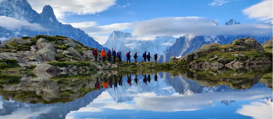
Day 3Day 3: To Elisabetta (6-8hrs)Descending through luscious pastures, there may be opportunities to buy Beaufort cheese from the shepherds. We later pass through the City of the Glaciers (La Ville des Glaciers) – a magnificent place where the green of the pasture is covered-up by the ice. Following a steady ascent we reach the Seigne passage (2516m) where the ruins of a customs hut remind us that we are crossing into Italy. Here there is a first glimpse of the Mont Blanc massif from the southern perspective, and descending to the Vallon de la Lée Blanche, there are good views of the fabulous limestone and snow pyramid of the Grand Combin and the Estelette and Lée Blanche glaciers. In the afternoon we will enter a rocky landscape in stark contrast to the lush pastures of this morning ........welcome to the Mineral Kingdom! Overnight Refuge with shower. Distance 15km/9.3mi, +960m/3150ft, -1250m/4100ft
Descending through luscious pastures, there may be opportunities to buy Beaufort cheese from the shepherds. We later pass through the City of the Glaciers (La Ville des Glaciers) – a magnificent place where the green of the pasture is covered-up by the ice. Following a steady ascent we reach the Seigne passage (2516m) where the ruins of a customs hut remind us that we are crossing into Italy. Here there is a first glimpse of the Mont Blanc massif from the southern perspective, and descending to the Vallon de la Lée Blanche, there are good views of the fabulous limestone and snow pyramid of the Grand Combin and the Estelette and Lée Blanche glaciers. In the afternoon we will enter a rocky landscape in stark contrast to the lush pastures of this morning ........welcome to the Mineral Kingdom! Overnight Refuge with shower. Distance 15km/9.3mi, +960m/3150ft, -1250m/4100ft
Day 4Day 4: To Berthone via Courmayeur (5-7hrs)In the enchanted valley of Veni, the enormous Miage glacier flows down into the beautiful Lake Combal. This is the Italian side of Mont Blanc that is offered to you from a truly beautiful standpoint and is perhaps the most enjoyable on the route. The trail continues along the flat valley floor overlooked by the serrated rock pinnacle of Aiguille Noire de Peuterey (3773m). There are some steep climbs, rewarded by magnificent alpine views, before we arrive in the town of Courmayeur, where you should definitely make the most of the amazingly delicious Italian Gelato (ice cream). Before arriving at the Berthone refuge (1970m) for the nights accommodation, we have a tough but rewarding 2-3 hour ascent. Overnight Refuge with shower. Distance 23km/14mi (possibly partly by bus), +1230m/3405ft, -1440m/4725ft Possible Spring Variant: Hike to La Visaille via the Col de la Seigne (Italian border), bus to Courmayeur (12km, 7hrs, 1000m/3280ft ascent, 700m/2300ft descent)
In the enchanted valley of Veni, the enormous Miage glacier flows down into the beautiful Lake Combal. This is the Italian side of Mont Blanc that is offered to you from a truly beautiful standpoint and is perhaps the most enjoyable on the route. The trail continues along the flat valley floor overlooked by the serrated rock pinnacle of Aiguille Noire de Peuterey (3773m). There are some steep climbs, rewarded by magnificent alpine views, before we arrive in the town of Courmayeur, where you should definitely make the most of the amazingly delicious Italian Gelato (ice cream). Before arriving at the Berthone refuge (1970m) for the nights accommodation, we have a tough but rewarding 2-3 hour ascent. Overnight Refuge with shower. Distance 23km/14mi (possibly partly by bus), +1230m/3405ft, -1440m/4725ft Possible Spring Variant: Hike to La Visaille via the Col de la Seigne (Italian border), bus to Courmayeur (12km, 7hrs, 1000m/3280ft ascent, 700m/2300ft descent)
Day 5Day 5: To Elena (5-7hrs)Today we have a major but scenic crossing to make, with great views over the 'Grandes Jorasses'. We begin by ascending to the flanks of Mont de la Saxe, followed by a steep ascent to a col immediately below the summit of Tete de la Tranche (2584m). From here the southern face of Mont Blanc is really quite spectacular. We will pass through the high mountain pastures of Arminal, Malatra and Arnuva, before climbing up to Elena refuge where there are excellent views to the glacier and mountains beyond. Overnight refuge with shower. Distance 16-18km/10-11mi, +704m/2310ft, -631m/2070ft Spring Variant: Hike to Chalet Val Ferret (5-6hrs, 18km, 750m/2460ft ascent, 550m/1800ft descent)
Today we have a major but scenic crossing to make, with great views over the 'Grandes Jorasses'. We begin by ascending to the flanks of Mont de la Saxe, followed by a steep ascent to a col immediately below the summit of Tete de la Tranche (2584m). From here the southern face of Mont Blanc is really quite spectacular. We will pass through the high mountain pastures of Arminal, Malatra and Arnuva, before climbing up to Elena refuge where there are excellent views to the glacier and mountains beyond. Overnight refuge with shower. Distance 16-18km/10-11mi, +704m/2310ft, -631m/2070ft Spring Variant: Hike to Chalet Val Ferret (5-6hrs, 18km, 750m/2460ft ascent, 550m/1800ft descent)
Day 6Day 6: Hike to La Fouly (5-6hrs)The sight of the Pré de Bar glacier, (a glacier that boasts a perfect tongue formation), is with us all the way as we make our way to the Grand Col Ferret (2537m), and the whole atmosphere is out of this world. Despite the climb it is a very rewarding section of the hike. The col marks the border of Switzerland and Italy and the trail becomes wider and more defined on reaching the border. The ascent from the pass takes you to the valley floor and eventually the charming village of La Fouly. Overnight Hotel with shower. Distance 13km/8mi, +624m/2047ft, -1100m/3608ft Possible Spring Variant: Hike to La Fouly (6hrs, 15km, 750m/2460ft ascent, 1000m/3280ft descent)
The sight of the Pré de Bar glacier, (a glacier that boasts a perfect tongue formation), is with us all the way as we make our way to the Grand Col Ferret (2537m), and the whole atmosphere is out of this world. Despite the climb it is a very rewarding section of the hike. The col marks the border of Switzerland and Italy and the trail becomes wider and more defined on reaching the border. The ascent from the pass takes you to the valley floor and eventually the charming village of La Fouly. Overnight Hotel with shower. Distance 13km/8mi, +624m/2047ft, -1100m/3608ft Possible Spring Variant: Hike to La Fouly (6hrs, 15km, 750m/2460ft ascent, 1000m/3280ft descent)
Day 7Day 7: La Fouly to Lac Champex, (5-7hrs)Today's walk highlights some amazing natural beauty. Dry meadows, pools of fresh water, herds of cows and wonderful chalets surrounded by flower-filled gardens greet you. Swiss village life is all around and whilst the dramatic scenery of previous days is not as apparent, it is a chance to experience the wonderful “Valais des Hommes”. Distance 15km/9.3m, +620m/1968ft, -750m/2460ft
Today's walk highlights some amazing natural beauty. Dry meadows, pools of fresh water, herds of cows and wonderful chalets surrounded by flower-filled gardens greet you. Swiss village life is all around and whilst the dramatic scenery of previous days is not as apparent, it is a chance to experience the wonderful “Valais des Hommes”. Distance 15km/9.3m, +620m/1968ft, -750m/2460ft
TripFinder compares the available catalog facts and can help with the booking. You travel under the operator's terms; final price and availability are confirmed before purchase.